


Description
Large map of the continent of Africa, by French map-maker Hubert Jaillot. The map is an
enlarged and updated version of a 1650 map by Nicholas Sanson, generally considered
the father of French cartography. It shows the entire continent, including Madagascar and
parts of southern Europe, Turkey, the Arabian Peninsula, and Brazil. In the Atlantic Ocean
are the Azores, Canaries, and Cape Verde Islands, as well as several islands in the
southern Atlantic. Also included is St. Helena and a “S. Helena Nova,” an island created
by Guillaume Sanson in his version of the map printed in 1669. It contains physical
features like lakes and mountains. Interestingly, the famous Mountains of the Moon, the
supposed source of the Nile River since ancient times, are not included here. Neither were
they on the original version of this map, published by Nicholas Sanson in 1650. Jailott has
also altered the river system south of the two great central lakes, where Sanson had
placed the Zambezi too far south.
In the upper left corner is a cartouche holding six scale bars. It also identifies Jaillot and
the date of the map, as does the ornate title cartouche in the upper right corner. The
cartouche includes a dedication to the Dauphin, who in 1692, when this map was made,
was Louis, son of Louis XIV. This Louis (1661-1711) was the Sun King’s oldest son.
However, the Grand Dauphin predeceased his father and never took the throne.
The original 1650 map was completed by Nicholas Sanson for his Cartes générales de
toutes les parties du monde, the first French world atlas. It draws upon Ortelius’s
sixteenth-century map of Africa, except that Ortelius’ two-lake structure in Central Africa
connected to both the Congo River and the Limpopo. Other sources for Sanson included
Gastaldi’s rendition of Africa and Blaeu’s 1608 map of the continent. Jaillot was in
partnership with Nicholas Sanson’s sons and he re-published many of the elder Sanson’s
maps. The enlarged map of Africa first appeared in 1674 and was re-printed due to its
exacting detail and aesthetic appeal.
This example period hand-colored and was framed behind glass in the 1970’s and comes
from an old German collection. Exposed image size is 34 3/4″ by 22 3/4″, 38 3/8″ by 26
1/4″ framed. The back of the frame is covered with craft paper, so the back of the map
has not been examined. The map very good with minor yellowing and age stains. Photos
unfortunately show a little glare because the map is under glass, but there are no major
defects. Price includes US Continental shipping.
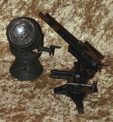 German Pre-WWII Tipp & Co. Model 8.8 cm Flak 36 Gun and Searchlight
 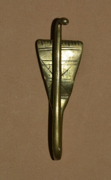 18th C Sword Hanger
 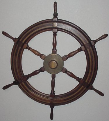 Ship’s Wheel from D-Day Blockship
 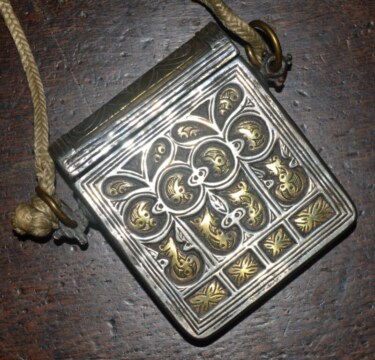 Ottoman Cartridge Box Palaska, Early 19th C